Pro Utility Surveys
Pro Utility Surveys for Reliable Detection
Get a Free Quote From Us Today!
We aim to get back to you in 24 hours.
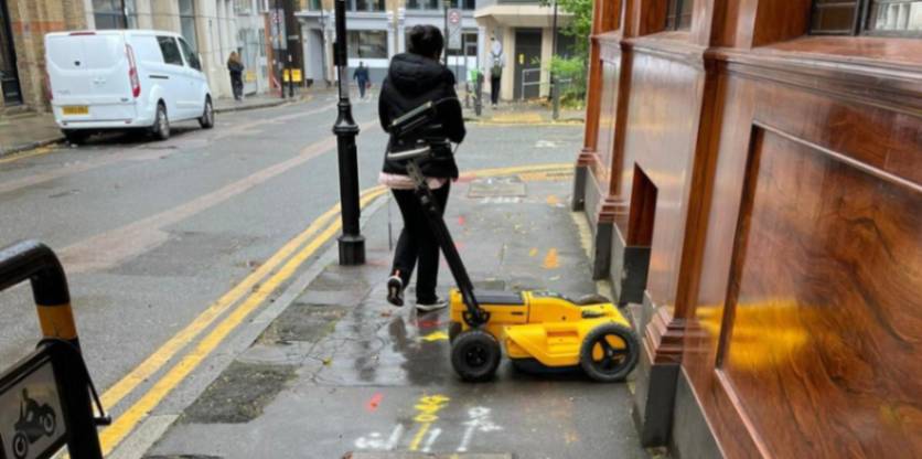
At Pro Utility Surveys, we deliver professional underground utility detection and mapping services across the UK. Our specialist team uses advanced electromagnetic and radar technology to identify buried assets like gas mains, power cables, and water pipes before groundworks commence.
By mapping the subterranean environment, pre-utility surveys ensure that your excavation team operates safely, which prevents catastrophic utility strikes and maintains project timelines.
What Services Are Included In Pro Utility Surveys?
A variety of detection and verification tasks are included in pro utility surveys to ensure total subsurface transparency:
- Electromagnetic Locating – Using radio-frequency transmitters to trace the exact route of conductive metallic pipes and power cables.
- Ground Penetrating Radar – Deploying radar pulses to identify non-metallic assets such as plastic gas pipes, fibre optics, and concrete conduits.
- Desktop Utility Record Searches – Analysing historic drawings from statutory undertakers to provide a preliminary overview of known buried assets.
- Topographical Integration – Linking subterranean data with surface features to create a unified geospatial map for architectural design.
- Post-Excavation As-Built Surveys – Verifying the position of newly installed services to provide an accurate record for future maintenance teams.
Why Should You Choose Professional Pro Utility Surveys Services?
Choosing professional utility surveys ensures that your project is built upon a foundation of absolute technical integrity and subsurface accuracy.
Our experts use regularly calibrated instrumentation and hold specific indemnity coverages that unvetted providers lack, which minimises the risk of strikes on high-pressure mains. This expert oversight maximises site safety, providing a clear audit trail and protecting your investment from the financial fallout of accidental asset damage.
Where Are Pro Utility Surveys Required Across Projects?
Our pro utility surveys are required across a diverse spectrum of environments, from individual residential plots to massive infrastructure regeneration schemes. The service is critical for brownfield sites and rail corridors where legacy records are often incomplete or entirely missing.
By mapping these locations, this process ensures that safe digging zones are established, which protects site personnel from high-voltage electrical discharges and prevents the legal liabilities associated with service disruption.
How Much Does Pro Utility Surveys Cost?
The total professional fee for pro utility surveys ranges from £800 to over £10,000, depending on the site acreage, utility density, and the PAS 128 quality level required.
Pricing is primarily influenced by the technical complexity of the soil for radar penetration, the number of survey man-hours needed for on-site tracing, and the technical depth of the digital drafting.
Contact Pro Utility Surveys to get customised prices for pro utility surveys at your property.
Get a Free No Obligation Quotation Today
When Should You Carry Out Pro Utility Surveys?
You should carry out pro utility surveys during the feasibility or pre-design phase, well before any piling, drilling, or trenching activities are scheduled. Early detection identifies conflicting buried services that could require expensive diversions if discovered mid-construction.
Engaging our team at this stage ensures your structural designs are feasible, which prevents project delays and satisfies the due diligence requirements of lenders and insurers.
Which Industries And Projects Benefit From Pro Utility Surveys?
Many professional sectors rely on pro utility surveys to manage the safety and financial risks of their physical developments:
- Civil Engineering Firms – Needing accurate data to design safe and compliant highways, bridges, and subterranean utility infrastructure.
- Residential Property Developers – Requiring verified site maps to plan housing layouts and ensure safe connection to local networks.
- Local Government Authorities – Commissioning surveys for school expansions, park redevelopments, and municipal infrastructure improvement schemes.
- Renewable Energy Contractors – Mapping cable routes for wind and solar farms to ensure efficient and safe grid connectivity.
- Archaeological Consultants – Detecting buried structures non-invasively to preserve historic integrity while assessing development potential.
How Quickly Can Pro Utility Surveys Be Completed?
Most projects handled by pro utility surveys are completed and delivered within three to five working days, depending on the scale of the site. Larger or more complex environments, like live industrial facilities, require more time in the digital processing phase to ensure all signals are correctly interpreted.
This efficiency ensures your project timeline remains predictable, providing your team with the high-resolution maps needed to advance the project without unnecessary administrative delays.
Request a free quote
What Safety Standards And Regulations Apply To Pro Utility Surveys?
Every inspection conducted by Pro Utility Surveys adheres to the rigorous PAS 128:2014 standard for underground utility detection and mapping. We also ensure full compliance with HSG47 guidance for safe digging and relevant health and safety regulations for site investigations.
Following these UK standards ensures your results are legally defensible, providing the insurance-backed certainty required for safe working practices on high-value development sites.
What Types Of Utility Surveys Are Available Through Pro Utility Surveys?
We deliver several distinct configurations of pro utility surveys to match the specific accuracy and compliance needs of your project:
- PAS 128 Level D – Compiling a report based solely on historic utility records for initial project desk studies.
- PAS 128 Level C – Validating record data through a physical site reconnaissance to identify visible surface features like manholes.
- PAS 128 Level B – Using EML and GPR to provide a non-invasive, high-accuracy map of all detected buried services.
- PAS 128 Level A – Confirming the exact depth and position of utilities through invasive vacuum excavation or slit trenching.
- 3D Utility Mapping – Delivering high-fidelity digital models in Revit or BIM formats for collaborative construction management workflows.
How Does The Pro Utility Surveys Process Work From Utility Detection To Reporting?
The technical workflow for pro utility surveys involves a sequence of site reconnaissance, technical data capture, and meticulous office-based processing to ensure geospatial integrity. Our geomatic engineers walk the site in a structured grid pattern, capturing signal reflections from subterranean features.
This methodology ensures every anomaly is logged with precision, resulting in a layered CAD drawing that acts as the indisputable technical evidence required for safe site handovers.
Contact Pro Utility Surveys for a consultation to get pro utility surveys tailored to your organisation’s risks and responsibilities.
speak with our team today
What People are Saying About Us
★★★★★
"Outstanding utility survey service with accurate underground mapping and very fast turnaround times."
Alex Dunn
London
★★★★★
"The survey team were knowledgeable, professional and extremely helpful throughout the entire project. We were very impressed with the final results."
Nicole Harper
London
★★★★★
"Excellent communication from the initial enquiry through to delivery of the final survey drawings. Everything was handled efficiently and professionally."
Darren Mills
London
★★★★★
"Reliable company with fantastic attention to detail and clear utility survey information that helped our project progress without delays."
Zoe Francis
London
Our Locations
We are proud to work nationally across the UK, allowing us to ensure we can provide services to you.
For a full list of counties we cover in the UK, see below.